

This is how it was seen from space the powerful volcanic eruption of an underwater volcano that caused a tsunami yesterday, Saturday, off the island of Tonga in the Kingdom of Tonga, located in the South Pacific Ocean.


Orbital sensors have taken pictures of the underwater explosive volcano that comes after a previous eruption of the "Tonga Honga" volcano in December 2021, but this event is seven times stronger than the December eruption and has so far sparked a tsunami in "Nuculofa", the capital of Tonga and Ecuador, which is 11,000 kilometers away. About the volcano The authorities of Australia, New Zealand and Fiji also issued warnings of further tsunami waves.
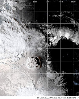
According to the Tonga Honga Geological Survey, plumes of gas, smoke and ash from the explosion (Picture 1) rose up to 20 kilometers into the air, resembling the detonation of a nuclear bomb.
Tonga is a volcanic island located 30 km southeast of the island of Nuku'alofa in Tonga. From northeastern New Zealand to the Republic of the Fiji Islands, it lies at an altitude of about 100 km above a highly seismically active area. Island arcs form at the convergent boundary as the Pacific plate dips below the Indo-Australian plate.
Experts have suggested that such a volcanic eruption is often caused by climate change, which contributes to an increase in the temperature of the sea and what is below, as natural chemical formations are produced in its waters, such as crystal, that block or trap large amounts of gases and help increase global warming, which in turn fuels natural disasters.
The Australian Seismological Agency said that the volcano erupted at dawn on Saturday at 04:10 GMT, about 65 km north of Nuku Alofa, the capital of the Kingdom of Tonga, and caused tidal waves 1.2 meters high.
#tonga